Sunday, May 8, 2011

Year 10 Thursday 5/5 Mapping

  1. What is it about the pressure system stalled over Australia that relates to the weather over the next 4 days? The high pressure system will stop rainy weather (relating to sunny condition in the graph below)
  2. What is the air pressure in each of the next 4 days for each of the capital cities? How does this correspond with the predicted weather for these cities? In next 4 days, cities will experience high pressure of weather.

Cities
Thursday
Friday
Saturday
Sunday
Sydney
1016
1012
1016
1017
Melbourne
1030
1027
1019
1022
Darwin
1014
1014
1018
1022
Perth
1018
1024
1022
1018
Adelaide
1028
1019
1028
1018
Brisbane
1016
1015
1017
1017


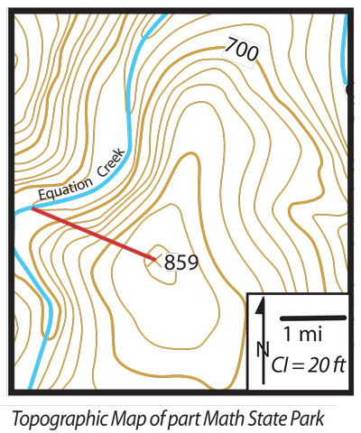
  1. What is the contour interval (sometimes abbreviated CI)? Convert to metric. The contour interval is 6.096m, Contour interval is the line between the line.
  2. What is the scale of the map? Convert it into the metric system. 2cm equal one mile or 1.6km
  3. What is the gradient of the line? Calculate in metric system.
        0.01125m


Sunday, May 1, 2011

Additional Question for 2002 school certificate

pg 22 Source H

What is the distance and local relief between the centre of the pine plantation and the factory?
5000 metres 
Give the Grid Reference for the Coal Mines as well as the local relief and distance between them.
GR843473, GR897475, 3500 metres
Give the Grid Reference for the intersection of the walking track and sealed road.
GR844440

pg 24 Source I
What is the air pressure at Sydney and Perth?
Sydney- 1019 hectopascals
Perth- 1011 hectopascals
What is the wind speed  and direction at Rockhampton?
Calm, No where
What is the Latitude and Longitude at Melbourne?
36S ,114E
What is the Latitude and Longitude where it is raining?
Darwin - 12E,130S
What is located in the SW just off the map?
Isobars

A city in five images

FINLAND
Helsinki is the largest city in Finland. It's the region of Uusimaa, located in southern Finland, on the shore of the Gulf of Finland, an arm of Baltic Sea. The population of the city of Helsinki is 588,941 (31, Jan 2011).making it by far the most municipality in Finland.

Helsinki is spread across a number of bays and peninsulas and over a number of islands. Population density in certain parts of Helsinki's inner city area is very high, reaching 16,494 inhabitants in kilometres in the district of Kallio.

I picked this image because this is a view seen from spot satellite. And also, you can see numerous islands, bays, and peninsulas in this image and i believe this is important to start with.


Helsinki Cathedral is an Evangelical Lutheran Cathedral of the Diocese of Helsinki, located in the exact centre of Helsinki. A distinct landmark in the scenery of central Helsinki, with a tall green dome surrounded by four smaller domes, the church was built in 1830-52, in neoclassical style.

The reason why i chose this image was because this Cathedral was built exactly in the centre of Helsinki, and it became one of the landmark's in Finland.


Finlandia Hall is a concert hall with a congress wing in Helsinki. The building was designed by Alvar Aalto. This work began in 1967 and completed in 1971. The main features of the building's exterior are the great horizontal mass of the building proper and the towering auditorium that rises above it. The main external wall material is Carrara marble and with copper roofs, which have acquired a green pantina, and teak window frames.

Another reason why i chose this picture was because that this building by Alvar Aalto, who built so many other buildings such as Auditorium of University of Technology.

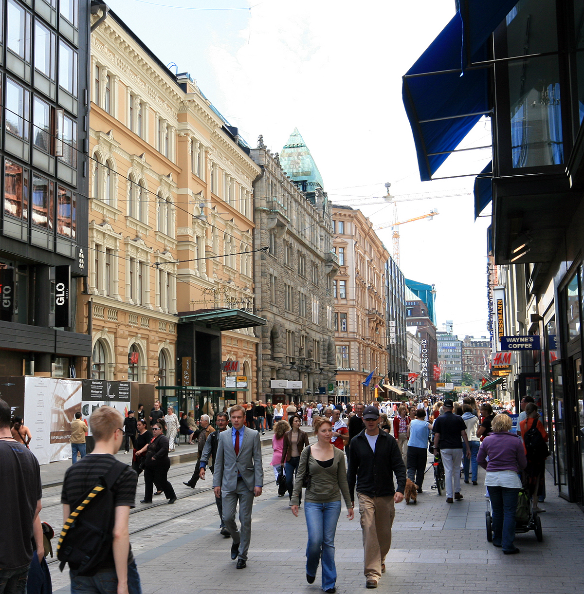
Aleksanterinkatu is a street in the centre of Helsinki. The street begins near the Presidential Palace and continues to meet with Mannerheimintie, the longest street in Helsinki. It runs past several famous buildings, such as Ritarihuone (the seat of Finnish nobility), the Helsini Cathedral.

This is just a street photo but still, this street is famous for the length, where it was linked with and shops around so many tourist visit this place.


Helsinki Swimming Stadium is a popular refreshment place for citizens. It is open from the beginning of May to the end of September. It is a popular place, and in summertime it is visited by about 5000 swimmers every day. The Stadium has three pools: a 50 metre exercise swimming pool, a jumping pool and a children's pool, and a small, shallow, round wading pool for small children a litter further away. The jumping pool has two 1 metre and two 3 metre high springboards, and a 1 metre plateau in front of the jumping tower. The area also has a water slide, a gym, a basketball field, a volleyball field, a table tennis table and a cafĂ©.

Wednesday, March 23, 2011

Urban Sprawl or Consolidation : Jordan Springs

1.  Urban sprawl, because in Jordan's Springs, there were nothing and everything is brand new and away from cities. Most homes were made of low density, and it promotes less pollution by using more of buses, and cars.

2. I think, this new development is positive for the people who doesn't have any job and poor. The people who doesn't have job, will find this new development a chance of them getting a new job.  '5300 jobs would be created.' For Sydney, i think they would think this new development would be negative because they have to share and lose resources, electric powers, and water supply to this new development. Also Sydney might think that they would lose some of their population to Penrith.

9.1 Australia- the urban nation

1. What is meant by the term 'urban sprawl'
urban sprawl is when as a city's population increases, the easy solution is to simply add more suburbs to the edge of the city to accommodate people.


2. What is meant by the term 'urban consolidation'?
Urban consolidation refers to a diverse set of planning set of policies intended to make better use of existing urban infrastructure by encouraging development within existing urbanised areas.

3. What is meant by a highly urbanised country?
Highly urbanised country is where most of the world's population lives in a certain country such as China, America.

4.List three statistics that suggest Australia is a highly urbanised country.
Sydney, NSW - 3502000 total population in 2001
Melbourne, VIC - 3162000 total population in 2001
Brisbane, QLD - 1508000 total population in 2001
and more.

5. What factors have influenced the location of Australia's capital cities?
because Melbourne and Sydney had the most population in Australia, they were having a debate which city should be the capital of Australia. However, they finally decided that they couldn't choose between Melbourne and Sydney therefore they measured the exact middle between two cities and constructed Canberra.

6. What is population density and how is it related to urban sprawl?
As i said in question 4, Sydney has 3502000 total population measured in 2001 and this record is related to the urban sprawl due to the fact that States such as NSW, and VIC has good, balanced weather and is comfortable to the people to live.

7. How do Australian cities compare to other cities in the world in terms of their population density?
Mumbai has 14350000 total population and the land area is really small, and Sydney has only 3502000 total population. Compared to cities such as Mumbai, Sydney's population is nothing.

8. Describe the Advantage, in terms of the provision of infrastructure, urban consolidation has over urban sprawl.
Because Sydney doesn't have that many people (3502000 total population) and the land area is 1687km2 it is wise and taking the advantage of the use of land.

9. How have urban planners responded to the issue of urban sprawl in Australia?
Urban planners have had to be innovative in their design of apartments and new estates to manage the impacts of population growth in cities. One of the changing aspects of Australian cities in the movement towards high population densities within the city. In a process known as urban consolidation, land within the existing city's boundary is developed with high-rise apartment complexes  townhouses and villa developments.

10. Refer to 9.2:
a) Which Australian city covers the greatest land are?
Melbourne (2080 km2)


b) Describe how population density is calculated.
Population density is calculated by dividing the population of the country to the square density so you divide both of them and you get the population density.


c) Rank Australia's cities in terms of their population density.
1. Sydney - 2076
2.Melbourne - 1520
3.Adelaide - 1374
4.Wollongong - 1251
5.Perth -  1221
6.Gold Coast - 1102


d) What proportion of Australia's 10 largest cities has a population density greater than 1000 people per square kilometres?
Sydney, Melbourne, Brisbane, Perth, Adelaide, Gold Coast, Canberra, New Castle, Gosford, Wollongong

11. Refer to 9.5 and discuss the opinions the residents in the detached housing in the foreground might have to the apartment buildings being constructed. What impact will the construction have on their community?
The construction will have a large impact as it will greatly overshadow the smaller houses around the large apartment developments. They will cause about 75% increase in the number of people living in that area. It will also cause shadowing over the smaller houses as the apartment buildings are large and bulky.

12. Discuss the advantages and disadvantages of living in a detached style housing estate compared to apartment living.
Well, i myself live in apartment buildings and advantages of living in a detached style house's have more space and it is good for kids environment. I prefer to live in a detached style houses because we have our own property and privacy is needed.

Monday, March 7, 2011

Year 10 : Urban Renew and Decay

Define the following terms and include an example of each and explain how your example relates the words:

Aesthetics
Having a sense of the beautiful; characterised by a love of beauty.


Safety
The quality of averting or not causing injury, danger or loss.


Slums
a thickly populated, run-down, squalid part of a city, inhabited by poor people.


Decay
To become decomposed, to decline in excellence


Reconstruction and renewal
Reconstruction: To construct or form again


Renewal: The act of renewing


Transport
To carry, move, or convey from one place to another


Suburbanization
To give suburban characteristics to


Environmental factors
The aggregate of surrounding things, conditions, or influences; surroundings


Light and Sound
Light: something that makes visible or affords illumination


Sound: the sensation produced by stimulant of the organs of hearing by vibration transmitted through the air or other medium.

7.8 Dune Revegetation at Stuarts Points

1. Name and Locate the coastal dune management area discussed in this unit.
Stuarts Point is a small coastal village located on the mid-north coast of NSW. The dune area is 5 kilometres long with its width varying from between 200 to 400 metres.


2. Using the material in the unit, construct a timeline that highlights the changes in the Stuarts Point sand dune ecosystem.
1893: Castle grazing destroys fragile vegetation
1893: Ocean breaches sand dune on 3 occasions
1965 (May) : Planting advice given to progress association
1965 (August) : Cattle grazing destroys vegetation again
1970: Stabilisation of sand dune through revegetation
1972: Controlling access to the dunes was implemented

3. Describe the role of the local community in managing the sand dune area.
Local community is putting their hand in together to complete the goal of re-establish the sand dunes. Local people volunteering to plant and taking care of revegetation.

4.Why is the sand dune are important to the people of Stuarts Point
Because it provides an important sand dune barrier that separates the beach from the Macleay River.

5.Using 7.35 describe the natural vegetation succession on sand dunes
The natural coastal dune vegetation succession consists of primary, secondary and tertiary species of plants, each adapted to the environmental conditions unique to coastal dunes

6. Explain why vegetation is so important in stabilising sand dunes.
Vegetation is so important in stabilising sand dunes because the plant roots dig into the sand and actually fixes the sand. It allows the sand to be locked in place by the plants and will not blow away.

7. What impact did cattle grazing have on the sand dune area?
They ate the vegetation so the dunes started to wear away

8. Describe the changes to the sand dune area that would have occurred after cattle grazing,. Identify the geographical processes that would have been altered as a result of the removal of vegetation from the dunes.
After the cattle grazing most of the dune would be bare sand, the geographical process altered would be the plants protecting the dunes from being blown away.

9. Identify the groups involved int he rehabilitation program
The Department of Lands, the Department of Public Works, the Macleay Shire Council, and the Soil conservation Service of New South Wales

10. Outline the stages involved in the management program undertaken to re-establish the coastal vegetation.
The first stage involved using a tractor to form a small foredune approximately 1.8 metres high. On top of this a dune-forming fence was constructed to help trap the wind-blown sand and establish the foredune. This dune was essential to protect the hind dunes and allow vegetation to grow. The foredune was then stabilised with coastal spinfex and marram grass. The next stage involved planting trees along the riverbank to stabilise the western margin of the area. After this was completed it was a matter of planting native seedings in the area between the foredune and the river bank. Initially, fast growing secondary species like coastal wattle and Casuarina equisetifolia were planted. Once they were established, coastal tertiary species like banksia, melaleuca and leptospermum were planted.


12. Use maps to explain the geographical process that would have caused the river mouth to silt up.
The Longshore Drift

13. Evaluate the success of the revegetation program in the following areas:
a) Stabilising the sand dunes.
Sand movement within the dunes is now negligible. A large foredune 3-4 metres high is present and covered with vegetation. This acts to protect the hind dune vegetation from salt-laden winds and erosion from waves. The hind dunes still run east-west as no mechanical work was conducted to repair the wind damage on the hind dunes when the area was revegetated. A coastal dune ecosystem has been reestablished on the dunes.


b) Protecting the Macleay River ecosystem.
The Macleay river ecosystem is now protected as a result of this


c) Benefiting groups from the local community.
The community fishing and tourism industry of the area has been restored to its full strength.

14.
Firstly, vegetation on sand dunes protects the dune from being blown away by winds. The vegetation succession that protects the dunes starts with the bare beach, then grasses and creepers on the incipient dune, then shrubs and short-lived trees on the fore dune and finally long-lived trees on the hind dune. Longshore drift as well as strong winds and heavy rain can cause a sand dune to move inland. Close off the dunes and re-plant vegetation and only re-open dunes once vegetation has grown back.